|
|

Hiking on the Sentier Cathare
From Languedoc to Pyrénées visiting the Cathar Castles
7 days / 6 nights - 13 days / 12 nights - 5 days / 4 nights
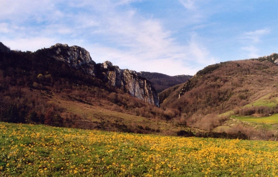
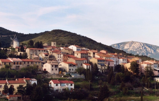
Departing from the Corbières (South of Carcassonne) to the Pyrenees mountains, the Cathar path is a link between Languedoc and Pyrennes. This route unveils different kind of sceneries such as garrigues, plateau, forests, gorges and mountians. This area was also the place where strong and tragic moments of the History took place when the Cathar people turned their back to the French Kingdom in Queribus, Peyreperthuse or Montségur are some of the castles remaining from this period.
Along these 7 stages, you walk surrounded by an amazing natural environnement on a path bordered by Cathar fortified castles. This superb hike takes you back to the medieval languedocian past.
Formules proposées
- Guided hike* : A qualified guide provides his services and presents the region, the natural sites and the local heritage.
- Self guided hike : We provide the maps and the road book. We reserve your accommodation and your meals.
* group : From 4 personnes
Les temps forts du voyage
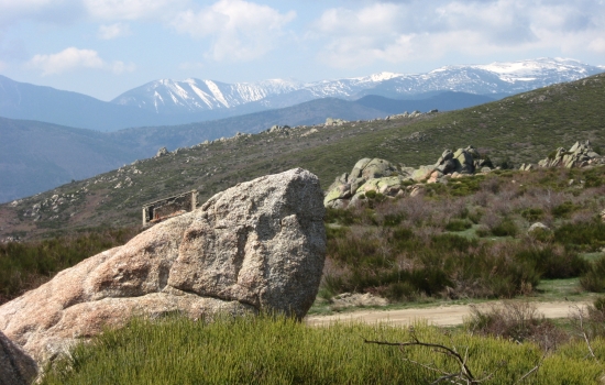
- a wide variety of landscapes: from the shores of the Mediterranean to the Ariegean Pyrenees
- the Corbières, its scrubland and vineyards
- The Hautes Corbières and its castles: Aguilar, Quéribus, Peyrepertuse...
- the possible visit of the castles
- the encounter with a land steeped in history


L'avis des voyageurs
Hello
Our journey has come to an end, under the blazing sun of the Mediterranean...
We are very satisfied with your service, the book was perfect and well-informed (elevation gains and losses, distances, different routes, etc.), the welcomes were authentic, warm, sometimes original, and the regional meals were very good and plentiful. In short, a very good trek to be repeated, perhaps on other trails with you.
Best regards.
Valérie and Claude - from the Rhône
Now that we're back home, we're very happy with our hike in this magnificent region. We met some very open people who love to talk and share their knowledge, and we thank you for your professionalism in organising our trip.
We had a wonderful holiday in Cathar country and will be back for more hikes, perhaps elsewhere, but always keen to discover the region.
Christine and Philippe from Charente
NIVEAU
This hike requires a good physical shape and a fair resistance due to the length of the stages and the difference in height.
Like every activity lasting few days, you should prepare yourself by walking everyday at least 30mn. Going to the gym or jogging would bring some benefit to prepare this stay.

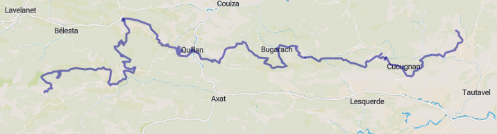
Le PROGRAMME
7 days tour
Day 1 : 22 km - difference in height: +750 meters
Day 2 : 24 ou 21,5 km - difference in height :+ 1095 or 1090 meters
Day 3 : 16 km - difference in height :+ 1015 meters
Day 4 : 23 km - difference in height :+ 720 meters
Day 5 : 22 km - difference in height :+705 meters
Day 6 : 19 km - difference in height :+530 meters
Day 7 : 18 km - difference in height :+: 520 meters
12 days tour
Day 1 : 28 km - elevation : + 550 m
Day 2 : 27.5 km - elevation : + 915 m
Day 3 : 22 km - elevation : + 750 m
Day 4 : 24 or 21.5 km - elevation : + 1095 or 1090 m
Day 5 : 16 km - elevation : + 1015 m
Day 6 : 23.5 km - elevation : + 720 m
Day 7 : 22 km - elevation : + 705 m
Day 8 : 19 km - elevation : + 530 m
Day 9 : 18 km - elevation : + 520 m
Day 10 : 13.5 km - elevation : + 505 m
Day 11 : 16,5 km - elevation : + 585 m
Day 12 : 21 km - elevation : + 490 m
Hike in loop
We can also organize a loop over 4 days (with south variant)
Day 1 : 20.5 km - elevation : + 805 m
Day 2 : 20 km - elevation : + 820 m
Day 3 : 25 km - elevation : +555 m
Day 4 : 19.5 km - elevation : 680 m
PERIODS
April from November
Slideshow
Slide 1 selected


| La prestation comprend |
|
• Accommodation in gite for groups or iin B&B. • Breakfasts, packed lunches and dinners. • The road book and the maps in the self guided trip • The transfer by mini-van at the end of the ride. |
| La prestation ne comprend pas |
|
• Personal expenditure • Cancellation and comprehensive insurance (4,5%) • The transfer of the luggage (feasible option) |
VENIR EN TRAIN
We all know the environmental impact of our car journeys. Going on holiday is a significant source of CO2 emissions, particularly because we generally travel long distances to get away from it all...
So if you are interested in "soft mobility", the Rivesaltes station is there to welcome you. A taxi or a minibus will make the connection with your accommodation.
Simulate your journey by train or contact us for further information.
Departing from the Corbières (South of Carcassonne) to the Pyrenees mountains, the Cathar path is a link between Languedoc and Pyrennes. This route unveils different kind of sceneries such as garrigues, plateau, forests, gorges and mountians. This area was also the place where strong and tragic moments of the History took place when the Cathar people turned their back to the French Kingdom in Queribus, Peyreperthuse or Montségur are some of the castles remaining from this period.
Along these 7 stages, you walk surrounded by an amazing natural environnement on a path bordered by Cathar fortified castles. This superb hike takes you back to the medieval languedocian past.
Program
7 days tour
Day 1 : 22 km - difference in height: +750 meters
Day 2 : 24 ou 21,5 km - difference in height :+ 1095 or 1090 meters
Day 3 : 16 km - difference in height :+ 1015 meters
Day 4 : 23 km - difference in height :+ 720 meters
Day 5 : 22 km - difference in height :+705 meters
Day 6 : 19 km - difference in height :+530 meters
Day 7 : 18 km - difference in height :+: 520 meters
12 days tour
Day 1 : 28 km - elevation : + 550 m
Day 2 : 27.5 km - elevation : + 915 m
Day 3 : 22 km - elevation : + 750 m
Day 4 : 24 or 21.5 km - elevation : + 1095 or 1090 m
Day 5 : 16 km - elevation : + 1015 m
Day 6 : 23.5 km - elevation : + 720 m
Day 7 : 22 km - elevation : + 705 m
Day 8 : 19 km - elevation : + 530 m
Day 9 : 18 km - elevation : + 520 m
Day 10 : 13.5 km - elevation : + 505 m
Day 11 : 16,5 km - elevation : + 585 m
Day 12 : 21 km - elevation : + 490 m
Hike in loop
We can also organize a loop over 4 days (with south variant)
Day 1 : 20.5 km - elevation : + 805 m
Day 2 : 20 km - elevation : + 820 m
Day 3 : 25 km - elevation : +555 m
Day 4 : 19.5 km - elevation : 680 m
PERIODS
From May to October
Trip highlights
- a wide variety of landscapes: from the shores of the Mediterranean to the Ariegean Pyrenees
- the Corbières, its scrubland and vineyards
- The Hautes Corbières and its castles: Aguilar, Quéribus, Peyrepertuse...
- the possible visit of the castles
- the encounter with a land steeped in history
- Guided hike* : A qualified guide provides his services and presents the region, the natural sites and the local heritage.
- Self guided hike : We provide the maps and the road book. We reserve your accommodation and your meals.
* group : From 4 personnes
Niveau
This hike requires a good physical shape and a fair resistance due to the length of the stages and the difference in height.
Like every activity lasting few days, you should prepare yourself by walking everyday at least 30mn. Going to the gym or jogging would bring some benefit to prepare this stay.
Travel advisories
Hello
Our journey has come to an end, under the blazing sun of the Mediterranean...
We are very satisfied with your service, the book was perfect and well-informed (elevation gains and losses, distances, different routes, etc.), the welcomes were authentic, warm, sometimes original, and the regional meals were very good and plentiful. In short, a very good trek to be repeated, perhaps on other trails with you.
Best regards.
Valérie and Claude - from the Rhône
Now that we're back home, we're very happy with our hike in this magnificent region. We met some very open people who love to talk and share their knowledge, and we thank you for your professionalism in organising our trip.
We had a wonderful holiday in Cathar country and will be back for more hikes, perhaps elsewhere, but always keen to discover the region.
Christine and Philippe from Charente
Slideshow
Slide 1 selected
| La prestation comprend |
|
• Accommodation in gite for groups or iin B&B. • Breakfasts, packed lunches and dinners. • The road book and the maps in the self guided trip • The transfer by mini-van at the end of the ride. |
| La prestation ne comprend pas |
|
• Personal expenditure • Cancellation and comprehensive insurance (4,5%) • The transfer of the luggage (feasible option) |
COME BY TRAIN
We all know the environmental impact of our car journeys. Going on holiday is a significant source of CO2 emissions, particularly because we generally travel long distances to get away from it all...
So if you are interested in "soft mobility", the Rivesaltes station is there to welcome you. A taxi or a minibus will make the connection with your accommodation.
Simulate your journey by train or contact us for further information.
- Guided hike* : A qualified guide provides his services and presents the region, the natural sites and the local heritage.
- Self guided hike : We provide the maps and the road book. We reserve your accommodation and your meals.
* group : From 4 personnes
Niveau
This hike requires a good physical shape and a fair resistance due to the length of the stages and the difference in height.
Like every activity lasting few days, you should prepare yourself by walking everyday at least 30mn. Going to the gym or jogging would bring some benefit to prepare this stay.